Fluid urbanism: Synthesising urban commons with water
– Riya Soni
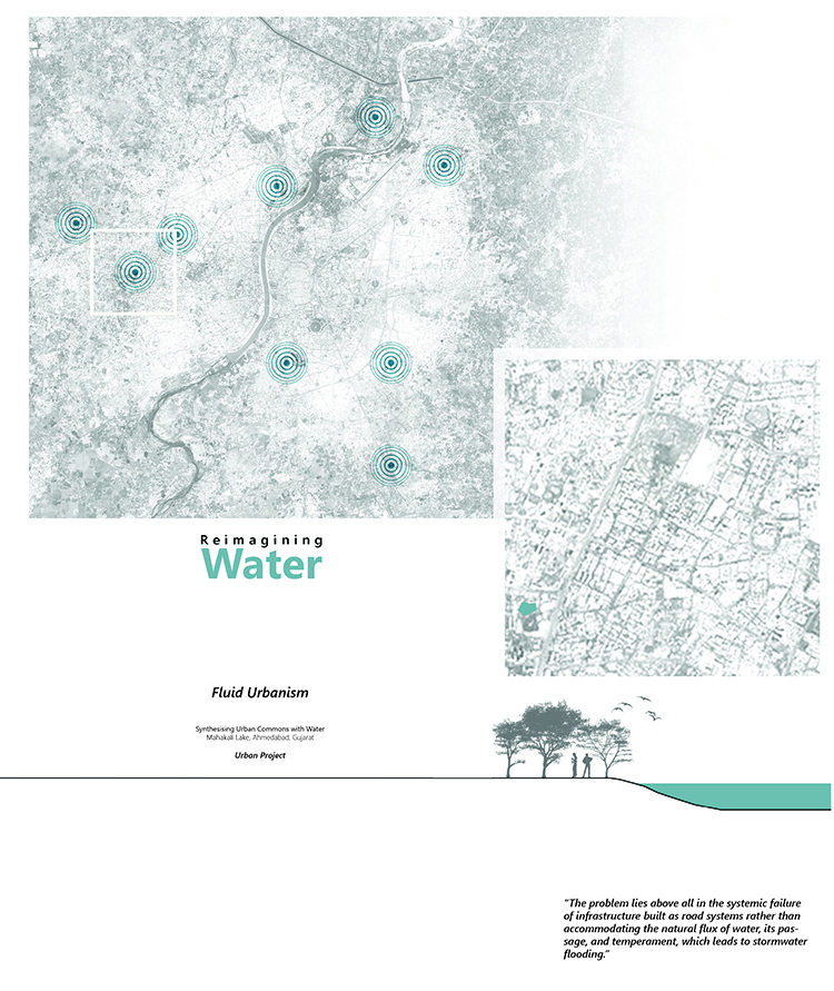
The Mahakali lake lies on the Sabarmati river’s western side, as a part of the Tekra-Talav system in western Ahmedabad. Tekra-Talav system is the relationship between high points and the low points of the city. This natural valley created due to the topography is essential in planning the city’s water system.
The lake was formerly fed by various other lakes during the monsoon season through an intricate drainage pattern between Shilaj, Thaltej, and Vastrapur and emptied in the Makarba Lake (Southern). The area that once catered to large parcels of farmlands has now become a densely populated residential site. The contrast from past to the present is essentially due to rapid urbanization that coincided with a shift from primary sector to secondary and tertiary sectors activities. In turn, it gave rise to loss of ecological value, and loss of socio-cultural aspects due to the local community’s movement, the fragmentation of the water system, a lack of management, and degradation in water quality. On further investigation of this cause-and-effect relationship of development, we understand that the underlying causes of these were majorly ignorance, lack of coordination, and loss of local knowledge.

Image 2. Creating a Myth | Imagining a Vision. Source: Author.
Rapid urbanization and its consequences resulted in a lack of interest and sense of belonging — although the socio-cultural markers are present, the connection is lost.
The problem lies above all in the systemic failure of infrastructure built as road systems rather than accommodating the natural flux of water, its passage and temperament, which leads to stormwater flooding. The transect of land between Vastrapur Lake and Mahakali Lake experiences intense flooding during the monsoon.
Together, this dialogue between effect and underlying causes on the site can be resolved by reconnecting the water system, developing a sense of belonging, and generating operative measures to ensure public engagement and participation.
The project’s vision is to re-establish the “Tekra-Talav” system by re-imagining seasonal streams and lakes as socio-cultural spaces. It seeks to revive the seasonal stream that leads to Mahakali lake. The lake currently lies in western Ahmedabad with alluvial floodplains. The contours effectively lie between 64m and 47m above sea level. The project aims to rethink the lake as grounds for engagement and interaction. Re-establishing this system essentially creates patterns of participation with the temperament of water throughout the seasons.

Image 3. Establishing Ritual | Site analysis. Source: Author.
Land use on the transect connecting the two lakes caters to a large spectrum, from smaller informal markets to large commercial buildings to housing. Hence, the activities are majorly driven by land use, i.e., people watching, play areas, relaxation spaces, etc.
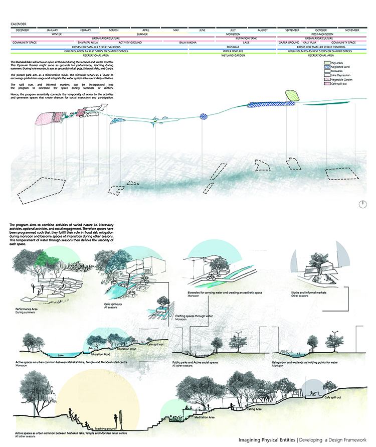
Reviving this seasonal stream is the core of the proposal: the hydrological connection between the lakes. The issue of flooding creates inaccessibility on the road. The basic program therefore revolves around creating a cohesive urban common between different interfaces present on the site. We integrate this to create smaller urban niches that hold water in the monsoon and act as activity grounds in other seasons. The flux of water defines the usage of the space. This further strengthens the connection that the users feel towards the space and to water.

Image 4. Imagining Physical Entities | Developing a Design Framework. Source: Author.
Hydrological enhancement
Once we identify the systemic flow, the need for smaller spaces to accommodate water becomes essential. Hence, we bring together small parcels of land (public spaces) and connect them with a system of bioswales. These smaller spaces are designed as holding points of water during high-intensity rainfall. The system is further detailed by integrating bioretention basins, wetland gardens, and sedimentation tanks. Hence a cohesive system consisting of bioswales, bioretention basins, rain gardens, wetlands, etc., have been put together as an elaborate effort to reconnect the water through the site.

Image 5. Translating ritual to space | Simulation | Crafting a place. Source: Author.
Socio-cultural enhancement
The culture of the area has lost its connection to the spaces. Thus, the proposal aims to generate a program that transcends into the user’s culture. This ranges from the festivals that have been important to the users to ecological niches that reconnect people to nature and give grounds for the community to develop. Space thus aims to become an urban common that reconnects people to these new urban socio-cultural markers.
The engagement and participation enable affinity and a sense of belonging to the water system. It is imperative that the two dialects, social interaction, and hydrological cycle, prevail cohesively to generate a continued interaction through time. These spaces celebrate the essence of the culture of the area, from the festivals to daily life.

Image 6. Master Plan | Crafting a place. Source: Author.
Operative measures
The hydrological system is ineffective when the users are not able to connect to the spaces. The social value of water needs to be integrated deeply within people to function to its potential over a longer period of time. Thus, the program essentially aims to connect the temporality of water to activities and generate spaces that create chances of social interaction and participation that, in turn, will develop a sense of belonging to the system.
The holistic connection generates operative measures and links that finally develop a sense of belonging to the system. The spaces are created with water, and during seasons with the absence of water, the system still embraces the memory of it by the type of vegetation, edges, and activities.

Image 7. Translating Form to Agenda. Source: Author.

Image 8. Translating Form to Agenda. Source: Author.

Image 9. Translating Form to Agenda. Source: Author.

Image 10. Re-Imagining crafted Entities. Source: Author.

Image 11. Re-Imagining crafted Entities. Source: Author.
Future outlook
This intricate connection between the hydrological system, the socio-cultural Layer, and the operative measures renders a prototypical solution. This solution can be further replicated and applied with modifications concerning the context, resolving flooding issues and reconnecting the extensive water system of Ahmedabad, further enhancing the water quality for communities that directly connect to this water for economic growth.
Conclusion
The layout works on multiple levels to achieve the vision. The isolated inserts connect and achieve hydrological workability, hence reconnecting the system. It holistically creates experiences and nuances that render a sense of belonging. This sense of belonging is evoked intensely by the activities and memories each of these isolated inserts brings out and creates operative measures to generate responsibility.
References
— Unnikrishnan, H & Mundoli, S & Nagendra, H. (2017). Making water flow in Bengaluru: planning for the resilience of water supply in a semi-arid city. Journal of Sustainable Urbanization, Planning and Progress. 2. 10.18063/JSUPP.2017.01.002.
– Pattanaik, D.(2006). Myth = Mithya: A Handbook of Hindu Mythology. 1st ed. India: Penguin India.
– Schama, S.(1996). Flow of myth. Landscape and Memory. 1st ed. New York: Vintage. pp. 243-279.
– Nideroest, T.,Sourav Biswas, S. (2019). When the Only Water Left is Gray: The Understanding of Landscape as a Framework and Medium to Approach Water Scarcity. From the South. 1st ed. Chile: Ediciones Universidad Del Desarrollo. pp. 163-175.
– Mathur, A., (2014). Design in the terrain of water. 1st ed. India: Applied Research & Design Publishing.
– Jain-Neubauer, J., (2016). Water design, environment and histories. 1st ed. Mumbai: Marg Foundation.
– Mathur, A. and Da-Cunha, D., (2006). Deccan traverses: the making of Banglore’s terrain. 1st ed. Delhi: Rupa & Co.
– Campbell, J. (1879). Ahmedabad- A study in Urban Indian History. Gazetteer of the Bombay Presidency Ahmedabad. 14th ed. Bombay: Government Central Press.
– Baviskar, A., (2007). Waterscapes – The Cultural Politics of Natural Resources. 1st ed. New Delhi: Permanent Black.
– Nagendra, H., (2017). The Lake That Became a Bus Terminus. Environment & Society Portal, Arcadia Collection: Water Histories, [Online]. Spring 2019, no. 2, 1. Available at: http://www.environmentandsociety.org/arcadia/collection/water-histories [Accessed 2 January 2020].
+
The work presented has been done under the guidance of Prof. Sandip Patil. His direction, encouragement and support has been of great value in the making of this.
Riya Soni has a Bachelor in architecture and is currently pursuing her Masters in Landscape Architecture at C.E.P.T. University. Ever since her Bachelor studies at the School of Planning and Architecture, Bhopal, she has had an inclination towards resolving systemic issues prevailing through architecture, urbanism and landscape. Her interests lie in the realm of experiential and tactical design. In her other world, Riya is an art enthusiast, trying to figure out individuals through her lens and brush.
Volume 4, no. 1 Spring 2021
