
Spatial manifestation of mobility tactics
– Philip Boos
Problem Observation and Research Questions
In 2017 we observe how access to walkable public spaces in urban areas is increasingly being restricted. One reason for this may be that motorized vehicles are usually granted more space and thus receive more attention than cyclists or pedestrians within the process of urban planning. These restrictions have a considerable effect on everyday mobility possibilities and social life, especially when focusing on walkability.
Much research on walkability has been conducted in technical manners and through quantitative approaches. These approaches include the application of various different indices. One example is the Walkability Index (Frank et al., 2005) which focuses on land-use mix, residential density and street connectivity. Another example is the Walk Opportunities Index (Kuzmyak et al., 2006), which combines information on the number, character, and desirability of key activities located within walking distance of a household. In addition, there has been research on the implementation of regional travel models focusing on the representation of walking activity (Clifton et al., 2016). Finally, there has also been research on the connection between the built environment and physical activity, such as walking (Saelens & Handy, 2008).
In contrast to the above mentioned quantitative approaches the present contribution does not apply any indices in order to measure walkability. Moreover, it focuses on public spaces for walking from a qualitative perspective and hereby attemps to fill a gap in the research. More specifically, it highlights how the inaccessibility of these spaces can be seen as resulting from top-down strategies which are implemented by the state or law and how the often insufficient design can be counteracted by individuals through bottom-up mobility tactics. On the one hand emphasis is placed on how the nature of walking functions as a spatial means to get from here to there. On the other hand, the contribution tries to reveal the social and participatory aspect of walking. In the words of Gehl (2011: 133) “[w]alking is first and foremost a type of transportation, (…) but it also provides an informal and uncomplicated possibility for being present in the public environment”.
Restrictions to personal mobility in the form of movement as well as inhabiting (being present in) the locality may be imposed upon the public in different ways. Physical barriers such as walls and fences, or inaccessible areas for pedestrians, such as roads that are frequently used by motor vehicles, form only few of these examples. At the same time restrictions may also be enforced in a more subtle way, for example through camera surveillance, controlling public space. The latter will not be covered in this paper.
In the light of visible restrictions and inaccessibilities mobility tactics gain increased importance. They can be interpreted and enacted in terms of resistance against mobility restrictions as well as creative action for mobility alternatives. In both ways they represent answers to top-down strategies. One goal of this paper is to visualize the implicit control over movement through an enforcement of having to use predefined mobility corridors such as roads, streets and especially ‘proper’ walkways or lanes. While usage of the latter is often enforced in publicly ordered space, the access to and usage of areas in between these corridors such as lawns and meadows or just patches of unused area is often not favored or possibly even forbidden. In drawing attention to these conditions, the paper tries to encourage the use of creativity in order to regain these spaces and highlight their use and usefulness individually, as well as collectively. The resulting walking behavior is not only a passive reaction to what is allowed and formally directed. In fact, it can be seen as an active application of tactics for regaining possibilities of movement. By increasing the visibility of these actions the public knowledge about the recurring restriction and the overall relevance of alternative propositions is likely to increase. From these observations the following two questions frame the further research:
-
A) What type of mobility tactics can be used for regaining access to public spaces creatively?
B) What are implications resulting from identified mobility tactics in terms of the degree of regained space and increased movement, practical applicability to mobility infrastructure and the degree of participation in urban planning processes?
Contextualization and Theoretical Perspective
Daily life (Alltagsleben), appropriation (Aneignung) and resistance (Widerstand) are the three central terms used by Krönert (2009), in order to describe Michel de Certeau’s Walking in the City, a chapter published in his seminal work Practice of Everyday Life (De Certeau, 1984). In describing the view of Manhattan from the top of the World Trade Center, De Certeau theorizes about the reality of social practices down in the streets and the bird’s-eye perspective from way above. He describes how the practices are “alien to panoptical, theoretical or visual constructions of geometrical or geographical space” and therefore represent an “intransparent and blind movability of the inhabited city” (De Certeau, 1984: 180-182 [translated by author]).
De Certeau (1984: 183-184) further explains how today’s cities are defined through a triple operation: (1) cleanliness through the suppression of impurities, (2) replacement of any kind of intangibility and persistence through synchronized systems, and (3) the creation of an anonymous and universal urban subject. In their entirety these three elements impose a certain form of organization through architectural and lawful rationalization, which at the same time includes a highly spatial component.
Just like any map created by individual actors and from individual perspectives, the elevated perspective enables only an abstract and simplified description of space. At the same time, it claims to be representing one singular and objective reality in its completeness. In de Certeau’s description urban users with their needs and opinions are only minimally visible from a top-down perspective. Down in the streets and on their routes from A to B these users “play with invisible spaces” (de Certeau, 1984: 182), which they inhabit and construct during everyday life. Thus they create and live certain mobility tactics, and by resisting “geometrical and geographical surveillance and control” (ibid.), they defy the strategies imposed on them from above. Individual solutions to spatial problems are found and re-enacted over and over until they serve a collective purpose and are thus manifested and stabilized within space.
Practical Application, Analysis and Results
After having theoretically approached the relation between restrictive top-down strategies and bottom-up tactics, the present section will focus on practical examples and their analysis in relation to the previously mentioned questions.
A key to resistance lies in enabling new everyday practices of walkability, which escape the logics of orderly and planned movement. At first this makes them invisible to the top-down strategies designed and employed by “the voyeur” (de Certeau, 1984: 180). Following this, a central point is then to suggest how these different alternatives for the everyday practice of walkability exist and how they can be enacted and set into perspective for public and collective use. This in turn opens up new possibilities for regaining usable space, transforming the visualized tactics into practical infrastructural changes and thus involving the public in policy adaption and planning processes. Practical examples can be seen in the following.
Image 1 shows how a walked shortcut is preferred to the destined way represented by a paved walkway. In this case the shortcut leads more directly to a block of non-pictured office buildings. While there is no supporting infrastructure for traffic regulation (traffic lights, or crosswalk) assisting the crossing of the horizontally running road, the horizontally depicted street also widens when intersecting with the vertically running street in the upper right corner of the image. Crossing the street at its smallest width (about the location of where the shortcut leads to in the upper left corner of the image) is safest and best possible for pedestrians. Even if the horizontally running street is not crossed, a shorter walkway is most often preferred to a longer one. In this case one implication for future urban planning may be the implementation of traffic regulation devices, or at least a crosswalk at the intersection of the roads.
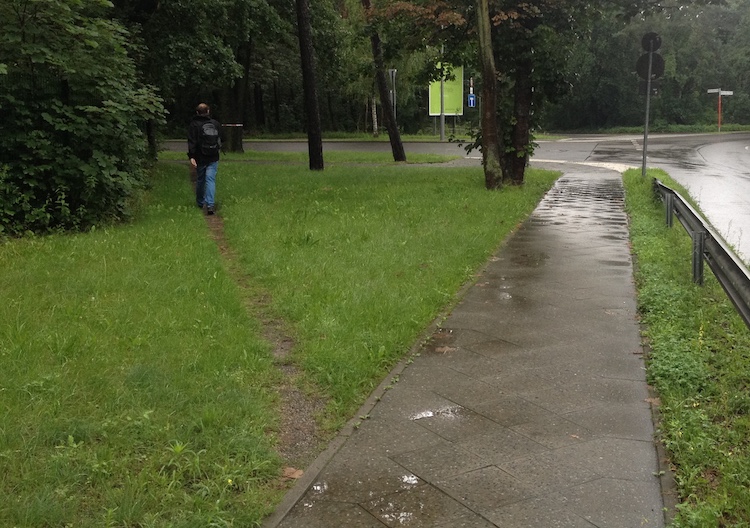
1. path exemplifying a shortcut (author’s own)
Image 2 shows the continuation of a paved walkway in the form of a walking path. This path connects an adjacent park with a paved walkway leading up to a bridge and ultimately over a river. In this case the pathway also represents a shortcut from the bridge directly into the park as well as to a larger paved area which is often used as a meeting point. The high frequency of path usage shown by the width of the path might be explained by the importance of the bridge as one of only a few ways for reaching the neighboring district on the other side of the river. On the other hand the importance of the park, given by its size and recreational features for urban dwellers, may also explain the path’s existence and direction.
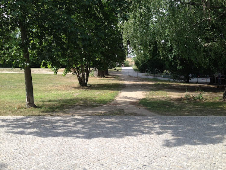
2. continuation of a paved walkway between a bridge and a park (author’s own)
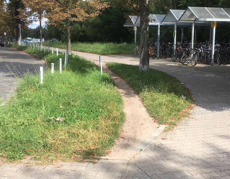
Image 3 shows a paved path sloping downwards from a bridge leading over a river. This path is shared by cyclists and pedestrians equally. Metal barriers have been implemented in order to slow down the cyclists and to encourage them to get off their bicycles in order to walk. The limited space for simultaneously passing (between) the barriers results in both, pedestrians and cyclists, passing them on either side of the pathway. The increased passing on the outsides of the barriers has led to a “digging out” of space each side of the barriers. The example shows how the repeated cycling and walking practices to the left and the right side of the metal barriers demonstrate the need for additional space. The example further shows that the practices have been acknowledged and subsequently incorporated into the urban fabric as the space on the (left) side of the depicted barriers has been paved.

3. additionally paved space following repeated bicycle and walking practices (author’s own)
4. bike practices hinting toward the missing of a bicycle lane (author’s own)
Conclusions
The given examples show how mobility tactics in the fields of walking and cycling can be widely applied while walking and cycling in public space. Several conclusions can be taken from the examples in the analysis:
1. Mobility tactics don’t focus on regaining space in general but more importantly on the increased use and a resulting temporary appropriation of space. This temporary appropriation leads to a higher visibility of issues and ultimately to an increased possibility of architectural and infrastructural adaption.
2. Examples three and four in particular show how repeated mobility practices in the form of tactics can lead to an implementation of collectively needed infrastructure in public urban space. These examples should encourage the public to practice mobility as a creative tool for increasing visibility for infrastructural needs such as shortening of distances, increasing traffic safety and enabling simultaneous usability of infrastructure.
3. By introducing little or no thresholds and drawing tactics from every day mobility practices, the degree of possible participation is very high. Individuals from any demographic can participate and in doing so collectively state the need for additional public space as well as the implementation of infrastructure reducing risk when using public mobility infrastructure.
References
– Clifton, K.; Singleton, P.; Muhs, C.; Schneider, R. (2016): Representing pedestrian activity in travel demand models. Framework and application. In: Journal of Transport Geography 52. Pages 111-122.
– De Certeau, M. (1984). The Practice of Everyday Life. Berkeley: University of California Press.
– Frank, L.; Schmid, T.; Sallis, J.; Chapman, J.; Saelens, B. (2005): Linking objectively measured physical activity with objectively measured urban form: Findings from SMARTRAQ. In: American Journal of Preventive Medicine 28(2). Pages 117-125.
– Gehl, J. (2011). Life between buildings: using public space. Washington: Island Press.
– Kuzmyak, J.; Baber, C.; Savory, D. (2006): Use of Walk Opportunities Index to Quantify Local Accessibility. In: Transportation Research Record, 1977. Pages 145-153.
– Krönert, V. (2009). Michel de Certeau: Alltagsleben, Aneignung und Widerstand. In: Hepp, A.; Krotz, F.; Thomas, T. (Eds.). Schlüsselwerke der Cultural Studies. Pages 47-57. Wiesbaden: VS Verlag für Sozialwissenschaften.
– Saelens, B. & Handy, S. (2008): Built Environment Correlates of Walking: A Review. In: Medicine & Science in Sports & Exercise, 40(7). Pages 550-566.
Philip Boos. B.Sc. Geography at Freie Universität Berlin, M.A. Urban Geography at Humboldt-Universität zu Berlin. Urban Geography and Urban Sociology research projects in Mongolia, Cuba and Lithuania. 2012-2013 student research assistant at the Center for Metropolitan Studies, TU Berlin and the Center for Technology and Society, TU Berlin. 2015-2016 research associate at the Fraunhofer Institute for Systems and Innovation Research. Since 2016 research associate at the Institute for Social Innovation, ISInova. Research interests include: Processes of social innovation and urban transformation, especially in the fields of mobility behavior and sustainable consumption.
Volume 1, no. 4 Winter 2017/18