Al-Manshiyya: Bordering and spatializations of difference on the vanishing Palestinian coastline
– Taylor Kathryn Miller
Walking north along the Homat HaYam Promenade in Jaffa, the entire Tel Aviv skyline comes into view with Mediterranean waves crashing against the old port’s walls. Families with young babies pause for pictures, bronzed 20-somethings play matkot (a popular paddle ball game similar to beach tennis) on the sand, and the occasional vendor hawking ice cream or drinks passes by. To the uncritical tourist eye, this is a veritable paradise; perfect weather, warm sand and cosmopolitan pleasures abound. But what these seaside vignettes of leisure and decadence omit is the historicity of the al-Manshiyya neighborhood upon which these spaces are built, as well as the ongoing dispossession of Palestinians in greater Tel Aviv. Consecutive eras of Zionist colonialism since the late 19th and early 20th century in this coastal city are generative of physical and psychic bordering through present day. The Hassan Bek mosque, Charles Clore Park and the Etzel Museum, all situated in what was historically al-Manshiyya, serve as sites to anchor this understanding of negation and erasure [Image 1].
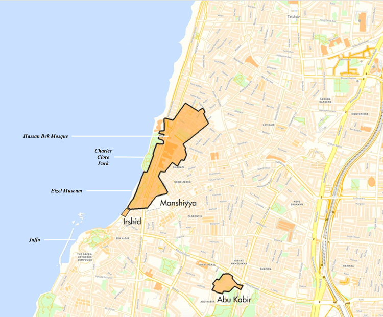
Image 1. Tel Aviv and its Palestinian Localities. Source: De-Colonizer, 2015.1
Spatializations of difference and exclusion are noticeable in the vernacular landscape and modern architectures which contribute to the “Judaization” of the neighborhood and a global aesthetic in these spaces that all but entirely expunge Palestinians’ connection to this land. My approach to visualizing and analyzing this ongoing annihilation and co-option of Palestinian history on Tel Aviv’s coast includes a close reading of a selection of archival photographs and documents of al-Manshiyya, primarily from the 1930s-2000s, as well as my practice-based methods including my digital photography and written/sketched observations from working and conducting research in the city (2014-2020). This combination of qualitative data will help illuminate the transformation of the landscape and built environment in al-Manshiyya, and aid in recovering details that the Tel Aviv municipality and neoliberalizing pressures of the redeveloping city have worked to disconnect and/or delete Palestinian identity from the space. While there is a host of scholarship on the politics of design and separation between Jaffa and Tel Aviv, little attention is paid to al-Manshiyya, which is located on the coast in the perceived boundary-region of the two.
The destruction of Jaffa and al-Manshiyya
The historiography of Jaffa frequently details recurrent destruction of the city—from its conquering by the Egyptians as early as 1496 B.C.E. to the Muslims in 639 and then the Crusaders; its fall to Ottoman rule in 1517 to Napoleon’s 1799 invasion and then the European economic expansion in the years following the Crimean War (1853-1856).2 By the turn of the 20th century, there was great interest in its port as a stronghold for new European economic activity, which fed a construction boom for foreign investment, trade and tourism. During this time of dynamic change, Jaffa quickly developed into a center for immigrants from neighboring Arab countries. Many Egyptians came to Jaffa with General Ibrahim Pasha in the 1830s, and these groups later founded the neighborhoods of Abu Kabir and Rashid, among others.3 This flurry of development in Jaffa Port also attracted early Zionist settlers to the region and increased tensions between these new Jewish communities and Indigenous Palestinians.
While the festering animosities were more complex than just “Zionists” vs. “Palestinians”—including disputes between Orthodox, Catholic and Armenian leaders, Hassidic Ashkenazi and Sephardi-Maghrebi Jews, and more—most notable was the need for the increasingly dominant Zionist immigrants to physically separate themselves from their Arab neighbors–Jaffa’s nearby neighborhoods, including al-Manshiyya (established in the 1870s). This was an impetus for the construction of new neighborhoods, and “led to new streets being cut through the existing orange groves, creating new spatial patterns that facilitated the urbanization of the region, including its villages.”4 The Jaffa and nascent Tel Aviv municipalities expanded to encompass these new communities, demonstrative of the determined beginnings of a Zionist spatial regime.
In 1887, the first self-described Jewish neighborhood in the Jaffa area, Neve Tzedek, was established and soon followed by Neve Shalom (1890), Mahane Yosef (1904), Kerem HaTeimanim (1905) and Ohel Moshe (1906). Also in 1906, the Ahuzat Bayit society (“Building Houses” society) was formed with its goal to establish “a modern Jewish urban neighborhood style in the city of Jaffa.”5 These middle-class Jews living in and around Jaffa engaged in Zionist public activity that laid the groundwork for urban colonization in the city for decades to come. Their “Judaization” of space included the construction of new markets, new logics of city planning, media outlets that conveyed the danger and perceived violent potential of neighboring Arabs and the use of the Hebrew language to reinscribe the linguistic and visual consciousness of these new “Jewish spaces.”
The ideological importance of Ahuzat Bayit and other budding Jewish strongholds to Zionist leaders was reaffirmed by financial backing from the Jewish National Fund (JNF), which facilitated land purchases and construction projects, attracted new Jewish immigrants from the Eastern Bloc/Europe and swelled these early Zionist communities exponentially. The new neighborhoods were not birthed from barren sands, as Zionist folklore wishes us to believe. Rather, Zionists strategically chose the land of Ahuzat Bayit for its fertility and proximity to Jaffa Port. The plot was originally Karm al-Jabali, a vineyard owned by the al-Jabali family, with ownership and agricultural records predating Ottoman rule.
A Russian-language handbook on the JNF (written in 1909, the year of Tel Aviv’s founding) “sheds light on the motivations underlying the Ahuzat Bayit project as well as its material, political, and national importance to the Zionist enterprise in Palestine”6:
- [Ahuzat Bayit seeks] to constitute, in our own country, as soon as possible, not only an economic force but a political one. There is no doubt that we will not be able to own the country if we do not own the land…The development of a Jewish urban community is without a doubt the most important stage in the bolstering of our position in the country.7
Indeed, the impetus of this land grab is ownership and demographic control with aims of eventual complete erasure of Indigenous Palestinians in the region; processes dispossession and reinscription inherent to settler colonialism. While this paper does not afford the space to attend to nuance of the contracts of sales, Shari’a Court records, or the politics of the labor force employed in these neighborhoods’ construction, it is necessary to explicate these earliest days of “modern” Tel Aviv as a project of calculated colonialism and nationalism, predating 1948 Israel state formation. It was not a city that bloomed from desert sands north of Jaffa (as the mythology of Tel Aviv upholds), but rather a wiping clean of arable Palestinian land to pave the way for urban, densely built space vis a vis swift annexation and redevelopment.
The al-Manshiyya of today is unrecognizable from its pre-1948 iteration:
- The neighborhood was built of a combination of one- and two-story buildings, stretching along the shore. According to a 1944 local police report, the population of Manshiyya numbered some 12,000 Palestinians and about 1,000 Jews, on an area of some 2,400 dunums. Although there were many citrus groves in the area, most of Manshiyya’s residents were engaged in commerce. [Manshiyya] had 12 bakeries, 20 coffee houses, 14 carpentry shops, 3 bicycle repair shops, 5 doctors, 7 factories, 7 jewelers, goldsmiths and silversmiths, 6 hotels, 10 laundries, 3 pharmacies, 3 printers, 6 restaurants, an electrical power plant and other commercial establishments. Most of them were located on HaTahana Street, in the Jewish market, al-‘Alam Street and Hassan Beq Street.8
Moreover, “at the entrance to the Manshiyya neighborhood…was one of the largest and most famous coffee houses in the area, Café Al’ansharah. It was a meeting place for political leaders, public officials and important businessmen.”9 The details of al-Manshiyya’s once-thriving commercial and cultural attractions evidence a dynamic Palestinian neighborhood prior to Zionist occupation.
However, in the early years of the British Mandate period (which spanned 1920-1948), al-Manshiyya became a hotbed of Arab-Jewish violence. Clashes along the Jaffa-Tel Aviv border occurred in 1921, 1929, 1933 and 1936 that altered the geographic, economic and social landscape of the region. Jewish residents sought to establish more rigid, reinforced borders between the “dangerous” predominately Arab neighborhoods of Jaffa and the increasingly sterile, “new” Tel Aviv. Formal separation/partition between the two was first proposed “in the report of the Peel Commission in 1937, and the “alarming news” was immediately deemed a “catastrophe” in the Palestinian Arab press, because it would “divide this Arab nation” and separate Jaffa and its surrounding Arab villages from the rest of the country.”10 This plan proposed the construction of a large iron railing between Tel Aviv and Jaffa, as well as suggestions for Tel Aviv to annex nearly the whole of al-Manshiyya, including the Hassan Bek mosque with aims of concentrating demographic and economic control up and down this stretch of coastline.
The Tel Aviv municipality continued to encroach upon and expropriate Palestinian land throughout the 1930s and 1940s with rapidity leading up to Israel state formation in 1948, often employing skillful and deceptive justifications for the annexation of land. The Etzel (Irgun), the Zionist paramilitary organization during the British Mandate, directly attacked al-Manshiyya on April 25, 1948 to cut the neighborhood off from surrounding Arab villages. Over 600 fighters with large amounts of grenades and ammunition attacked at dawn. Residents tried vehemently to resist, but failed due to lack of weaponry and available fighters. Al-Manshiyya fell on April 28 after scores of Palestinians were wounded or killed, and the neighborhood was severed from Jaffa. The following day, the Etzel detonated the al-Manshiyya police station, planting the Jewish (Israeli) flag on its ruins.11 Following the neighborhood’s capture, power was transferred to the Haganah (the main Zionist paramilitary organization, which became the core of the Israel Defense Forces (IDF)), which expelled remaining inhabitants to Jordan, Egypt or by sea to Gaza. The rest of al-Manshiyya’s infrastructure was demolished in stages, with some homes spared for newly arrived Jewish immigrants to settle.
While the Nakba (meaning “catastrophe” in Arabic, when at least 750,000 Palestinians were expelled from, dispersed or executed within Palestine by Zionist forces) and its myriad violences left all of the 26 Palestinian Arab villages in and around Jaffa emptied or destroyed, urban planners and politicians in Tel Aviv took this critical turning point as an opportunity to reconstruct these sites in the image of Zionist ideals [Image 2].
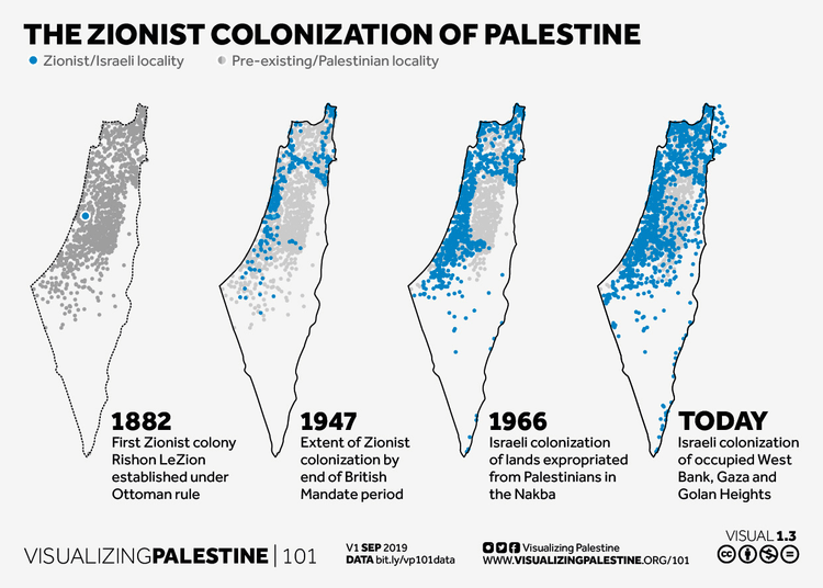
Image 2. The Zionist Colonization of Palestine. Source: Visualizing Palestine, 2019. 12
While the nuances of the physical, psychological and ecological damages of the Nakba cannot fit into this piece, the significance of the terror during this period – through present day – inflicted on the land and its people must not be forgotten.13 The aim of erasure of Palestinian Indigeneity in Jaffa and beyond is explicitly detailed:
- According to one soldier-turned-architect who participated in the capture of the neighboring village of Salama, “From the beginning the Municipality decided to erase historic Salameh and build in its place something completely new.”…the discourse of “erasure and reinscription,” as James Holston has termed the guiding force behind modernist planning, was a major theme in the planning and architecture of Tel Aviv.14
A city from the dunes, or space rewritten
In subsequent eras of Zionist colonialism since the Nakba, physical and psychic bordering is continually reproduced. This is evidenced not only by critical historians and theorists, but by the few remaining Palestinian elders who experienced these erasures and traumas and the ongoing dispossessions first-hand. A short documentary on al-Manshiyya produced by Zochrot (an NGO whose name means “remembering” in Hebrew) in 2011 highlights the stories of Eftekhar Turk and Saleh Masri, both from Jaffa. Eftekhar painfully recalls the near constant displacement and instability her family experienced once Zionist forces began attacking, “Within al-Manshiyya we were expelled six times. You go out into the street and see people running. Everyone was looking for a vehicle to get out.”15 The film includes photographs of the neighborhood following the Nakba, which help illustrate the widespread destruction she and others faced. The decimation of this neighborhood created, in essence, a blank slate for Zionists to redesign and rewrite the space and its storied history [Image 3].
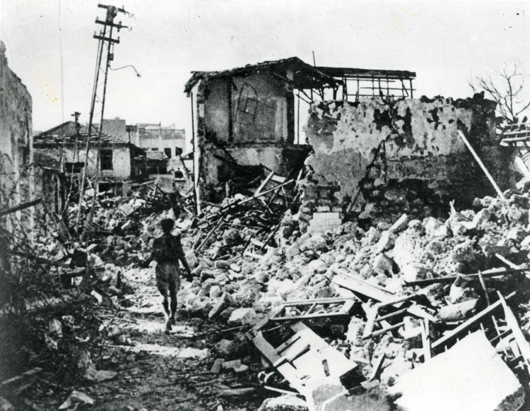
Image 3. Al-Manshiyya Quarter. Source: Institute for Palestine Studies, 1948.16
Throughout the 1950s, al-Manshiyya became a site for Israeli architectural experimentation as remaining Arab houses were razed to the ground. By 1963, the municipality sought to transform the space into a modern commercial center, and what remained of the neighborhood was completely demolished, except for the Hassan Bek mosque. The mosque, constructed in 1915-16 under the Ottoman governor of Jaffa, Hassan Bek al-Jabi, has served as a site of resistance since its inception. A waqf (an Islamic endowment of property to be held in trust and used for a charitable or religious purpose) was established on a larger parcel of land in northernmost al-Manshiyya prior to building the mosque. Hassan Bek developed a plan that was “initially meant to check the development of this urban Jewish rival [Achuzat Bayit neighborhood] to Jaffa and to prevent the possibility of Jews advancing their building activities on the northern, still undeveloped, shores north of the center of the city of Jaffa.”17 The site quickly emerged as a landmark for Arabs in the region, and the minaret was even used as a strategic location for Palestinian snipers firing against the Etzel in April 1948.
While the architecture of the mosque endured the violences of the Nakba, most of the congregants were maimed, killed or forced into exile; in this catastrophe’s aftermath the mosque was deserted, and all cultural and religious activities were halted. In subsequent years, al-Manshiyya and the mosque “underwent a dramatic change as a result of new planning policies and the development of new master plans for the city.”18 Shrouded in themes of “modernization” and “urban planning”, these Zionist desires of transforming the former Palestinian neighborhood into a prominent Jewish Israeli enclave used planning as a central tool to implement its ideology and as an efficient mechanism of spatial and demographic control,19 thus concretizing cultural and political hegemonic dominance.
The new State of Israel created a legal framework to approve development plans of “abandoned” properties (The Absentees Property Law of 1950) and ensure channels for confiscation, co-option and ease of transformation of Palestinian property,20 such as the Hassan Bek mosque, into projects deemed supportive of the state’s goals, revealing how “hegemonic forces operating within a capitalistic and nationalistic logic were co-conspiring, in tandem with planning policies…to annihilate the mosque.”21 These acts of Israelis negating the Nakba’s violences which forced Palestinians to flee, as well as the ensuing measures aimed at seizure of the Hassan Bek mosque, reflected attempts to deterritorialize al-Manshiyya and reinscribe the site and its environs in the image of a modern Jewish city.
In the following years, the Hassan Bek mosque was blighted; it was far from the beacon of community and religious engagement its founder conceived. On October 21st, 1981, the Tel Aviv-Jaffa Local Planning and Building Commission unanimously approved a renovation plan that intended to replace the mosque with a shopping mall. A protest prayer was organized for the first time since 1948—coalescing over 2,000 Muslims from Jaffa and beyond—and the Council for the Arabs of Jaffa (known as the Rabita) was formed.22 Nassim Shaqar, the first chair of the Rabita, described the revival of the mosque’s resonance:
- Since the mosque was the last relic which attests the Arab existence in the neighborhood of Manshiyyah we in the Rabita wanted to preserve it. As you know, if one sees such a building one understands that Tel Aviv was not a desert, as we are told in national history books, but rather one learns that there was a settlement here and it had a mosque, and it had a cemetery, and it had a life, and someone ruined that life! This is why the struggle over the mosque is highly symbolic…And why was the mosque neglected and not returned to its community for prayers? Because, in such a way it would collapse and with it the last memory of the Palestinian community of Tel Aviv will be lost.23
The plans to dramatically alter the mosque were scrapped after the community’s determined resistance efforts. But ongoing strife surrounding claims to ownership and management persisted. On June 1, 2001 during the Second Intifada, a suicide bombing occurred across the street at the Tel Aviv Dolphinarium dance club, killing 21 Israelis. The Israeli police released a statement saying that the perpetrator may have sought refuge at the Hassan Bek mosque, which triggered massive anti-Arab demonstrations outside its walls.
This generated a new phase of physical and psychic bordering in al-Manshiyya. The rapid transformation of the landscape and built environment that occurred on the ruins of al-Manshiyya has severely isolated the mosque and grounds from all other activity nearby.
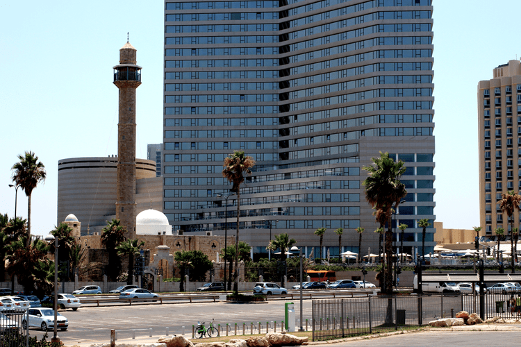
The mosque starkly appears as an isle unto itself [Image 4]; separated from the Mediterranean shore by multiple lanes of traffic and two parking lots reserved exclusively for paying beachgoers. Here, the mosque’s congregation is physically isolated from views of the sea and freedom of mobility is curtailed by dense traffic and restrictive vehicle fees. The psychic bordering, a term used throughout this paper, refers to the psychological barriers/inhibitors built into or read within the space that underscore otherness and difference. This is evidenced in the municipality’s disregard for the sanctity of the mosque’s grounds and the practice of Islam on-site; the construction of multiple bars, loud dance clubs and an absence of dress code in such immediate proximity actively encourages lewd, abrasive behavior in beach-goers and further sequesters the mosque’s congregation, especially during the summer months when Ramadan (the Islamic for fasting, prayer, community and introspection) occurs. In addition to this, the layers of fences and walls around the mosque’s grounds, barriers like the highway median and swaths of concrete for two parking lots spatially and emotionally reinforce a them versus us, separate and unequal logic of partition.
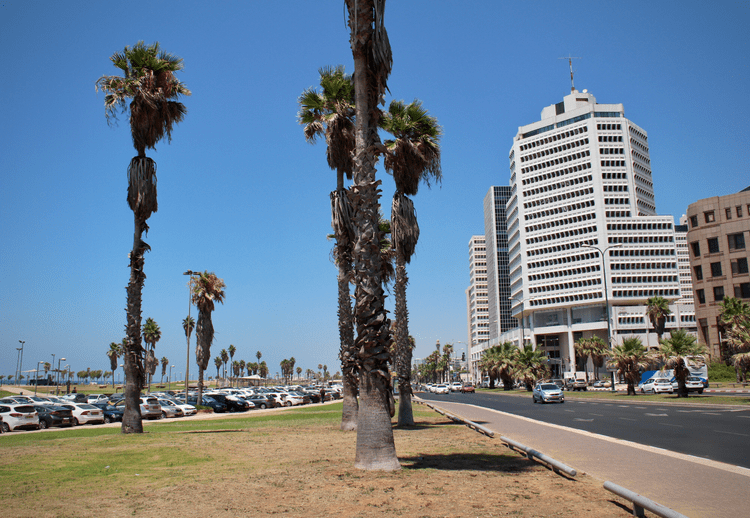
Image 4. Parking lots, medians and multiple lanes of traffic surrounding Charles Clore Park with Hassan Bek mosque in the distance. Source: Author, 2018.
In my own experiences near the mosque during months of fieldwork wayfinding in the area, I bear witness to the ruination of al-Manshiyya and the totalizing erasure of Palestinian Indigeneity in the space. All of the ground is either paved thickly with asphalt or fortified by concrete, so as to deny the neighborhood’s ruins the slightest chance to breathe. Even the sand on the shore is trucked in from elsewhere. There are no visible signs in Arabic (almost all signage is written in Hebrew and/or English). While the Dolphinarium’s jaw-like structure is now demolished, the retaining walls and nearby surfaces scrawled with spray paint and or wheatpastings indicate an anywhereness or placelessness, as there is no sliver of localized culture and history evocative of Palestinian identity and belonging [Images 5 – 7]. Moreover, I was unable to detect any didactic markers or signage around the mosque’s perimeters for tourists and pedestrians to take note of its architectural and historical significance. It appears like a purposeful oversight by the municipality with aims of removing the opportunity to pique both city inhabitants and travelers’ curiosity, and this acts to “ignore it away” out of the city’s collective memory. During my most recent visit to the city, the Dolphinarium had been flattened and piles of rubble were left behind chain link fencing and the security cameras’ gaze; a site-in-stasis, yet a display of hegemonic force manifest in the built environment–denying user-ship to the public and actively refusing to repatriate Palestinian land. Undoubtedly, it is a space awaiting a multimillion-dollar hotel development catering to an international tourist crowd. A set of visitors made purposefully unaware of the palimpsest of Palestinian history upon which they’ll throw parties, sunbathe and contribute to the ongoing occupation of territory.
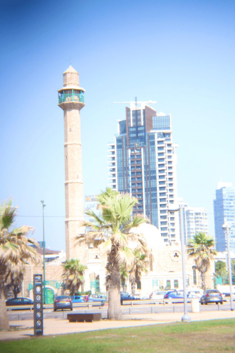
Image 5. Hassan Bek mosque, photographed with Holga lens from across Kaufmann Street in Charles Clore Park. Source: Author, 2018.
Image 6. Layers upon layers of physical and psychic bordering between the mosque and the sea. Source: Author, 2015.

Image 7. Dolphinarium rubble, photographed with Holga lens. Source: Author, 2018.
Public spaces, ethnonationalist inscriptions, and reification by museum exhibitions
Across the street from Hassan Bek mosque, Charles Clore Park was constructed during a time when Tel Aviv stakeholders worked relentlessly to globalize the city; this site serves as a second example of negation and erasure of Palestinian history on the land of al-Manshiyya:
- [The park was] named for a Jewish British philanthropist, designed by E. Hillel, the landscape architect and poet, [and] established on most of Manshiyya. The rolling surface of the park formed “dunes” concealing the rubble remaining from the demolition of the neighborhood, which had been pushed to the seaside. In the Zionist tradition of making the wilderness bloom, the dunes were covered with grass and colored green…[this project] is an example of how the process of destruction, which started with an attack on the neighborhood, continues even now, [under] the guise of “planning” or “development.”24
This is the park that the two parking lots serve, noted in the isolating organization of the city around Hassan Bek mosque; it has pay-per-vehicle entry for access to the beach, sea and other leisure activities. Planning and design measures (re)produce and preserve spatial control by expressing materializations of ideologies that manipulate the ways people experience space,25 and Charles Clore Park is a vast expanse of coastal land reconstructed with what I assume as the intent to eradicate what remained of al-Manshiyya, along with any trace of its erasure. A double negation of the history of this landscape. My digital photographs serve as reference to the ongoing obliteration of Palestinian history in the neighborhood, as well as the municipality’s vested interest in Israeli and international investment in and development of the city.
Between 1948 and 1953, Tel Aviv tripled its open public spaces and parks in the city due to the annexation of al-Manshiyya and surrounding neighborhoods.26 In the 1960s, the land of al-Manshiyya was eyed by developers as a key commercial prospect due to its economic potential and proximity to the beach. The imperative behind the urbanization and Judaization of this space was threefold: 1) to express the high modernism and international, tourism-driven agenda of the city, 2) to bolster a cutting-edge image of the nation-state of Israel and 3) to legitimize the demolition of the existing continuity of the Arab fabric of south Tel Aviv and Jaffa.27 Throughout the 1970s and 1980s, neoliberalization of the city accelerated privatization processes with the rapid emergence of luxury high rise condominiums, boutique stores and trendy bars capitalizing on the prime location while the remainder of the al-Manshiyya coastline property landed in the municipality’s hands.
Charles Clore first opened in 1974, but it is difficult to uncover Anglophone documentation about its cost, labor practices and reception/reactions by displaced Palestinian communities. It is possible that this lack of data is due to the overarching Zionist narrative of building Tel Aviv “from the dunes”; as though pre-1948 Palestinian urbanity was nonexistent, and the park was constructed on “surplus” or “open” space. Spare the slightest slope where the overwatered grass meets the paved corniche, there is a physical and metaphorical flattening of the grounds; where local dialects as well as cultural and historical intricacies are all buried beneath labyrinthine sidewalks, picnic ramadas and highly-manicured non-native plant species—decimating the ecological sanctity and distinctiveness of this Palestinian land [Image 8].
Image 8. The re-redevelopment of the shoreline promenade, Charles Clore Park. Source: Author, 2018.
As similarly read in the sequestering and othering of Hassan Bek mosque, the redevelopment of al-Manshiyya’s ruins into Charles Clore Park indicates:
- The state’s ideological foundations of territorial Jewish domination and supremacy [as] spatially achieved in [Tel Aviv-Jaffa] not only through warfare, but also through the transformative greening designs of everyday landscapes in parks. Greening in large open spaces of Tel Aviv-Jaffa fabricated a new landscape, where rolling lawns and sinuous paths conceal and naturalize the state’s acts of depopulation, appropriation, and ruination.28
The park is a landscape of figural disturbance and an embodied, everyday expression of Israeli cultural hegemony. The destruction and re-urbanization of al-Manshiyya is not unique to the coastal region—it mirrors spatial critiques of structural and botanical ruination elsewhere in Palestine, so it must be underscored:
- Rather than assert the homogenous and consensual status of colonized space, the ambiguity of emptiness and ruination exposes the deep uncertainties and contradictions that are inherent in the production and perpetuation of ethnonational spatial regimes… The slippages and ambiguities that plague the symbolic domain of spatial production signal the volatility of the hegemonic structure and point to critical instances in which it is forced to defend and reassert its ideological foundations.29
In Charles Clore Park, both the landscaping and the leisure structures’ (workout and playground equipment, walking paths, beach cabanas etc.) aesthetics entirely obscure traces of the Nakba, which actively negates Palestinian connection to the land [Images 9-10]. The absence of cues of commemoration of lives once lived here is a purposeful crafting of the current inhabitants’ and tourists’ consciousness. The visual impression of this space is intended to reaffirm the Zionist drive to tame, beautify and develop the land in the image of a Jewish homeland while signaling the prosperity and proliferation of ethnonational dominance.
Image 9. View of Charles Clore Park looking south towards Jaffa, an expanse of seared summer surfaces. Source: Author, 2018.
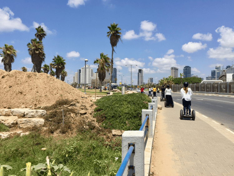
Image 10. Looking north along Kaufmann Street, Charles Clore Park and the seashore to the west. Source: Author, 2018.
The Etzel Museum is located just steps away from the beach in the southern part of Charles Clore Park. The project’s architects—Amnon Schwartz, Dani Schwartz and Amnon Niv—used three walls of the last remaining Palestinian structure amidst al-Manshiyya’s ruins to construct the foundational frame for the museum in 1978. Completed in 1983, the Beit Gidi (House of Gidi) was dedicated “to the memory of those Etzel fighters who died ‘liberating’ Jaffa in 1947-1948.”30 Paraphernalia of the paramilitary organization fills the exhibits depicting the massacre at Deir Yassin, the Altalena affair and the conquest of Jaffa.31 The architectural project and the exhibitions it contains are rife with incongruities and contradictions. Dark glass walls schematically complete the building to the rectangular form it once was; yet, the juxtaposition of the austere panes against the centuries-old stone read less of a symbol of integration and more of one of co-option and violence enshrined in urban form [Image 11].
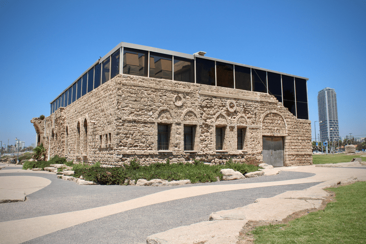
Image 11. Etzel Museum. Source: Author, 2018.
The exterior of the building is without didactic or any details regarding its original architects, inhabitants, or the conditions contributing to the stones’ disrepair:
- In the case of the Etzel Museum…not only were the destructive forces created by the building’s own namesake, ‘Gidi’ Faglin, and at the hands of individuals who also designed it, but its aesthetics evoke something of a ‘retroactive ruin theory’–the idea that, throughout all the years that the old Arab house existed, it was merely waiting in earnest, building up to the moment of its destruction and its subsequent role as decoration within Sir Charles Clore Park. This feeling stems from the fact that the Etzel Museum, as the one remaining ruin of Manshieh, does not preserve even one moment or one historical occurrence which took place in or around the building prior to its destruction.32
For the unknowing tourist or city dweller, this blatant denial of Palestinian historicity in and around the museum and its grounds is productive of the anywhereness similarly observable near Hassan Bek mosque and throughout the rest of Charles Clore Park. Lacking these integral details of al-Manshiyya’s previous inhabitants, one could presume the stones were brought in specifically for the museum’s construction, or to bolster the illusion of Israelis building the shoreline from the barren dunes. A stone plaque cemented into the exterior wall of the museum reads: ETZEL HOUSE / IN MEMORY OF LIBERATORS OF JAFFA / THE MUSEUM OF JAFFA’S LIBERATION.
This enshrinement of Zionist ideology is dated “1983” for the year of the museum’s opening. The plaque is like a tumor on the historical building’s wall; a mark of Judaization (vis a vis superimposing Hebrew text onto an Arab surface) and a perennial reminder of violence against Palestinians in al-Manshiyya. Moreover, the plaque is intentionally “distressed” for an aged aesthetic that makes it appear to have endured battles and seem weather-worn by Mediterranean coastal winds, lending to the falsity that Zionist pioneers were the only side that endured hardships yet “emerged victorious” and must be commemorated for their perseverance and courage. Though there is much more to be unpacked about the weaponry, photographs, maps and replica models in the exhibition space, it is essential to note that the museum’s main display centers on the Battle for the Conquest of Jaffa. Palestinian refugees are only mentioned in this storyline as part and parcel of Zionists overtaking Jaffa for the sake of security. The museum text reads:
- The goal of the conquest was to remove the threat of Jaffa becoming a naval base and military base for the Arab armies. On 28 April 1948, after three days of fierce fighting, the large Manshiyyah neighborhood was captured including its Hassan Beck Mosque, which threatened Tel-Aviv. Other parts of the city continued fighting with the help of 4,500 British soldiers. However, Etzel mortars continued their endless bombardment on the center of Jaffa causing its inhabitants to escape en masse.33
This hollow and ambiguous recount of the battle obscures the details and atrocities of the Etzel’s actions against Palestinians in al-Manshiyya. Emphasis is placed on securitization for burgeoning Tel Aviv and implicates an evil-doing other against whom the Zionists needed to defend.
Conclusions
The space surrounding Hassan Bek mosque and the Etzel Museum, as well as the ground under Charles Clore Park, has been flattened and purposefully emptied of physical remnants of its Palestinian history. Zionist manipulation and reinscription rendered these sites devoid of cultural or historical signifiers that would hint of Palestinian lives previously lived in al-Manshiyya. These violences are especially manifest architecturally, as explored through the example of the museum. Rotbard (2015) emphasizes, “There is something astonishing about the unabashed manner in which the [Etzel] museum uses architectural means to dramatize the act of conquest, the takeover, the looting, the rape of the ‘Bride of the Sea.’”34 He furthers:
But the forced compression of the glass box onto the ruins of an emptied Palestinian home is not only chilling for what it represents historically; it lends the museum an expressive vigor which encourages this unbearably flippant usage of the ‘old and new’, detaching it from the political context while still part of it. Strangely, the building uses the ruin and the aesthetics of the ruin in order to cover and conceal the full extent of the destruction done. The building tells the truth about the rape and murder of the city of Jaffa, but it lies at the same time by cloaking this bloody drama in ‘architecture’ and ‘environmental art’.35
By stripping the building of its contexts and folklore as a structure in a once-thriving neighborhood—continually excluding indigenous communities through the narratives conveyed in the exhibitions while rebranding the site as a bastion of Zionist might—the Etzel Museum is a site of negation and erasure of Palestinian history in al-Manshiyya, a perverse and ongoing process of Zionist settler colonialism.
My practice-based methods are scaffolded by counter-hegemonic imperative; to help reveal and center how, despite being west of the so-called Green Line (the 1949 Armistice Lines established following the Nakba) Tel Aviv is undeniably occupied territory. While the brute and now-routinized violences beyond the so-called Green Line register the territory as highly publicized, propagandized and over-theorized “conflict zones,” it is necessary to also turn critique toward the sea; to parts of the country that are not frequently associated with aspects of the deeply sedimented “Palestine-Israel Conflict,” nor the overt workings of fascist, apartheid systems of domination, surveillance, and physical/psychological warfare in the West Bank and Gaza. For so often, “[when] discussion is situated on Palestine or Palestinians, history often begins in 1967, ‘Occupation’ is (at best) the ontological category for thinking through Palestinian relations with Israel, and geography begins and ends with the ‘Green Line.’”36 It is imperative to turn to/include the globalized, cosmopolitan and hyper-stylized shore and urban built environment that masquerades as “open,” “accepting” and “liberal.” Ergo, Tel Aviv–and particularly the depopulated and redeveloped area of Jaffa, northward to al-Manshiyya–is occupied territory. This naming, this analytical shift, aims to “undermine…a problematic distinction between the perceived ‘active’ settler colonialism of the occupied territories and the ‘historic’ settler colonialism inside the internationally recognized state of Israel. It further stresses the impossibility of settler colonialism to ever cease being actively settler colonial–it being, indeed, always in the state of becoming.”37
It is a city where decades of ongoing destruction, (re)construction and reinscription of space actively conceal, erase and/or rebrand Palestinian culture and the built environment. By anchoring this research on the Hassan Bek mosque, as well as the landscape and vernacular architecture of Charles Clore Park and the Etzel Museum, I work to emphasize how Zionist settler colonialism pervades throughout al-Manshiyya and can be rendered visible despite Israelis’ efforts to depict these pasts as unnecessary or altogether nonexistent. These sites are generative of physical and psychic bordering from pre-Nakba eras through the contemporary moment, as evidenced by the purposeful construction of walls, parking lots, Hebrew signage and redevelopment projects in this part of the city that obliterates the history of the neighborhood, while actively excluding today’s perseverant Palestinian communities. The dispossessions and demolitions of Palestinian space and subsequent reinscriptions of Zionist ideology on/in the city are discriminatory and a form of occupation in everyday functions of Tel Aviv.
Notes
1. De-Colonizer (2015). Tel Aviv and its Palestinian Localities (with three research sites added by the author). [online]. Available at: https://www.de-colonizer.org/tel-aviv-and-its-palestinian-locali [Accessed: 26 Sept. 2020].
2. LeVine, M. (2005). Overthrowing Geography: Jaffa, Tel Aviv, and the Struggle for Palestine, 1880-1948. Berkeley: University of California Press.
3. Ibid.
4. Ibid. p. 52.
5. Ibid. p. 61.
6. Ibid. p. 62.
7. Ibid.
8. Zochrot, (2014). Al-Manshiyya Neighborhood (Yaffa). [online] Available at: http://zochrot.org/en/village/56077 [Accessed 21 Feb. 2018].
9. Ibid.
10. LeVine, M. (2005). Overthrowing Geography.
11. Zochrot, (2014). Al-Manshiyya Neighborhood (Yaffa).
12. Visualizing Palestine (2019). The Zionist Colonization of Palestine. [online]. Available at: https://101.visualizingpalestine.org/visuals/zionist-colonization-palestine [Accessed: 26 Sept. 2020].
13. Khalidi, R. (2020). The Hundred Years’ War on Palestine: A History of Settler Colonialism and Resistance, 1917-2017. New York: Metropolitan Books.
14. LeVine, M. (2005). Overthrowing Geography.
15. Zochrot (2011). Manshiyya (المنشية). 6:32. Available at: www.youtube.com/watch? v=KGUjQE68_vI. [Accessed: 22 Feb. 2011].
16. Institute for Palestine Studies (1948). Al-Manshiyya Quarter. [online]. Available at: https://www.paljourneys.org/en/timeline/media/9487/al-manshiyya-quarter#&gid=1&pid=1 [Accessed: 26 Sept. 2020].
17. Luz, N. (2008). The Politics of Sacred Places: Palestinian Identity, Collective Memory, and Resistance in the Hassan Bek Mosque Conflict. Environment and Planning D: Society and Space, 26(6), p. 1039.
18. Luz, N. (2008). The Politics of Sacred Places. p. 1040.
19. Ibid.
20. Erakat, N. (2019). Justice for some: Law and the question of Palestine. Stanford: Stanford University Press.
21. Luz, N. (2008). The Politics of Sacred Places. p. 1042.
22. Luz, N. (2008). The Politics of Sacred Places. p. 1045.
23. Luz, N. (2008). The Politics of Sacred Places. p. 1047.
24. Zochrot, (2014). Al-Manshiyya Neighborhood (Yaffa).
25. Hatuka, T. and Kallus, R. (2006). Loose Ends: The Role of Architecture in Constructing Urban Borders in Tel Aviv-Jaffa Since the 1920s. Planning Perspectives, 21(1), pp. 23-44.
26. Meishar, N. (2017). Up/rooting: Breaching Landscape Architecture in the Jewish-Arab City. AJS Review, 41(1), pp. 89-109.
27. Hatuka, T. and Kallus, R. (2006). Loose Ends.
28. Meishar, N. (2017). Up/rooting. p. 100.
29. Leshem, N. (2013). Repopulating the Emptiness: A Spatial Critique of Ruination in Israel/Palestine. Environment and Planning D: Society and Space, 31(3), p. 533.
30. Roṭbard, S. (2015). White City, Black City: Architecture and War in Tel Aviv and Jaffa. London: Pluto Press. p. 129.
31. Ibid.
32. Roṭbard, S. (2015). White City, Black City. p. 132.
33. Boord, O. (2016). The War of Independence Exhibited: A Study of Three Israeli Museums. Israel Studies, 21(1), p. 90.
34. Ibid. p. 133.
35. Ibid. p. 134.
36. Hawari, Y., Plonski S., & Weizman, E. (2019). Seeing Israel Through Palestine: Knowledge Production as Anti-Colonial Praxis. Settler Colonial Studies, 9(1), p. 160.
37. Milner, E. (2020). Devaluation, Erasure and Replacement: Urban Frontiers and the Reproduction of Settler Colonial Urbanism in Tel Aviv. Environment and Planning. D, Society & Space, 38(2), p. 281
Taylor Miller completed her BFA and MA in Art & Visual Culture Education at the University of Arizona. As a PhD candidate at the University of Arizona in the School of Geography, Development & Environment, her research interests include the contemporary cultural and political geography of Tel Aviv and Marseille, arts-led gentrification and the aesthetics of occupation in the urban built environment. Her transdisciplinary projects incorporate photography, poetry & critical architectural and urban theory.
Volume 3, no. 3 Autumn 2020